Your address is a mathimatical calculation of the Lattitude and Longitude of your GPS. It devides the workd into blocks that are the size of alarge Tile and give you and address for them to 10 characters. Only 4 more than the average UK Post Code.
This means you can be much more accurate as to where you want that parcel drop off to be (i.e the exact location of my amazon box), or where you want to meet someone… (on this side of the park bench) or where you berried that hidden treasure when you were a 12 year old pirate! (no more “Gotta be a here somewhere!!!!”).
Benefits are
- No Database Needed – its maths
- Super fast to calcualte – Its maths
- It not based on words – Its maths
- No need to know how to spell – Its maths
- Not based on English – (it is latin characterset though hmm not too bad)
- It represent a 66cm(east west) wide by 33cm high (north south) rectangle… so its that accurate at 10 characters
- It has a secret…. The areas can aggregate each Character, as you reduce each character you muliply each area by 36. For example at the 6th character the rectagle is roughly half a kilometer high
The Math
For you current location
Baseline globe extents
• Latitude spans 180 ° (−90 ° … +90 °)
• Longitude spans 360 ° (−180 ° … +180 °)
Subdivision rule
• Each step chops every rectangle into 6 parts north-south and 6 parts east-west, so one rectangle becomes 6 × 6 = 36 smaller rectangles.
• After n steps, each original side has been split into 6ⁿ segments.
Therefore, after n subdivisions:
latitude height per rectangle = 180 ° ⁄ 6ⁿ
longitude width per rectangle = 360 ° ⁄ 6ⁿ
Now plug in n = 6 and n = 10.
n = 6
6⁶ = 46 656
latitude height = 180 ° ⁄ 46 656 ≈ 0.003858 °
longitude width = 360 ° ⁄ 46 656 ≈ 0.007716 °
n = 10
6¹⁰ = 60 466 176
latitude height = 180 ° ⁄ 60 466 176 ≈ 2.98 × 10⁻⁶ °
longitude width = 360 ° ⁄ 60 466 176 ≈ 5.95 × 10⁻⁶ °
If you like ground distances near the equator (where 1 ° ≈ 111 km):
• After 6 subdivisions: about 0.003858 ° × 111 km ≈ 428 m tall and 0.007716 ° × 111 km ≈ 857 m wide.
• After 10 subdivisions: about 2.98 × 10⁻⁶ ° × 111 km ≈ 0.33 m tall and 5.95 × 10⁻⁶ ° × 111 km ≈ 0.66 m wide.
So the rectangle edges shrink from roughly half-kilometre scale at the 6th split to roughly half-metre scale at the 10th.
If you read this far, you probably are thinking how this can help
The other form of address is what we call the Location ID, this breaks the world into 4 rather than 36. Why is this needed… well quite simply it give you more granularty… you get to decide how accurate you want your calculation to be and it will give you more layers to get to the size of block you want. You can read how it has been used in a app called Litter Logger
Total Number of block of about 1.5 quadrillion at the 25th level… the 50th level would be a nano meter… not that our gps’s are that accurate 😀
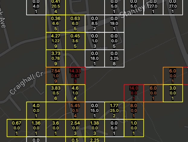
Here is an example of this being applied to calculate the Daily average of litter in an area. This can be aggregated super fast at different levels simply by aggregating at different “Lengths” of the address. Thes are 20 meters blocs, but as the map zooed out so did the aggregation… i.e. you could zoom in and show it at 1 meter blocks if you wanted, or zoom out to see the entire countries averages.